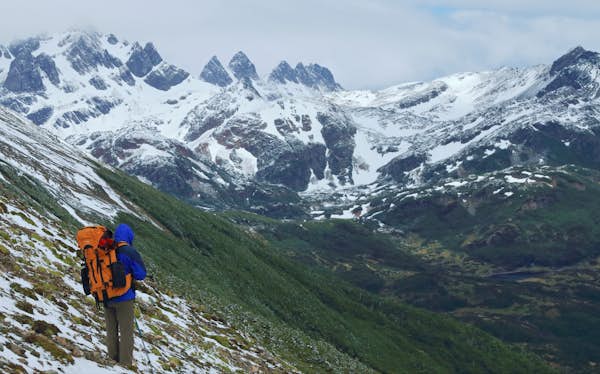
Patagonia puts on an extraordinary display of nature at its rawest. Alternately covered in scrubland and ancient woods, carved up by glacial rivers and streams, filled with wildlife and pocked with myriad ice-melt lakes whose surfaces range from pale blue to navy, the region covering a massive chunk of southern Chile and Argentina is almost synonymous with outdoor adventure.
Whether you’re looking to rough it on multiday treks through pristine wilderness, to bounce from hut to hut in epic national parks, to exert yourself on day hikes before returning to the comfort of a boutique guesthouse or to just stretch your legs while road-tripping along the Carretera Austral, Patagonia can accommodate.
First-time visitors should keep in mind that hiking in Patagonia and Tierra del Fuego is largely confined to the peak and shoulder seasons of November to late March. If you want to hike off the beaten path, make sure you’ve left word with someone about your proposed route, take a tent sturdy enough to withstand the famous Patagonian wind (called La Escoba de Dios, or “God’s Broom”) and all the supplies you’ll need. During any hike, all-weather gear is a must (in Patagonia, it’s normal to experience four seasons in one day – or even one hour). Accommodations must be booked many weeks in advance for the high season from December through February.
Advertisement
This delightful dozen of the best trails across this spectacular territory are just waiting to thrill you.

1. Laguna de Los Tres, Parque Nacional Los Glaciares (Argentina)
Best for scenery and a sense of accomplishment
Distance: 25km (15.5 miles); round trip
Estimated time to complete: 8–10 hours
Level of difficulty: moderate
Start: El Chaltén
Only accessible on less windy days, this day hike is the most scenic and challenging of those around southern Argentina’s compact trekking capital of El Chaltén. The well-marked trail in Parque Nacional Los Glaciares ascends through ñire (a small southern beech) woodlands from the north end of El Chaltén’s main street, past the turquoise Laguna Capri and across boggy terrain to Campamento Poincenot, popular with climbers. An exposed trail zigzags up the mountain side to the glacial lagoon, where you can get excellent bonus views of the jagged 3405m (11,171ft) Mt Fitz Roy and maybe dip your feet in the icy water.
2. Dientes del Navarino Circuit, Navarino Island (Chile)
Best for a demanding trek
Distance: 53.5km (33.2 miles); loop
Estimated time to complete: 4–5 days
Level of difficulty: difficult
Start: Puerto Williams
On Chile’s southernmost permanently inhabited territory (across the Beagle Channel from Tierra del Fuego), this demanding trail loops around the pinnacles of the Dientes del Navarino mountain range. Requiring wild camping and excellent navigation skills, it’s best done in a clockwise direction with at least one other companion. The trail cuts across bare stony plateaus, skirts glacial lakes, traverses lowlands and crosses exposed mountain passes. Highlights include expansive views of the Beagle Channel from Cerro Bandera and Paso Virginia (near the beginning and end of the trek, respectively). Be sure to watch your footing on the rapid descent from the latter pass.

3. W Trek, Parque Nacional Torres del Paine (Chile)
Best for an overnight hike in Torres del Paine
Distance: 74km (46 miles); one way
Estimated time to complete: 3–5 days
Level of difficulty: moderate
Start: Refugio Grey End: Las Torres viewpoint
The shorter of the two multiday treks that Chile’s iconic Parque Nacional Torres del Paine is known for, this route is shaped like the letter that gives it its name. To start, you’ll take a boat across Lake Pehoé, then hike through woodlands along the banks of Lago Grey to the icy monolith of Grey Glacier before retracing your steps. You then pass along the shores of glacial Nordenskjöld Lake and climb up French Valley for an up close look at Los Cuernos, the park’s bell-shaped mountain range. A final stint through scrubland, across hills and up the Ascencio River valley brings you to the trident peaks of Las Torres.
You can either camp en route at designated campsites, go from refugio (bunk hut) to refugio, or even glamp along the way. Due to the park’s immense popularity, all accommodations and camping spots have to be booked months in advance. The W is best hiked west to east if you’re camping, so that you’ll have used up most of your supplies before tackling the ascent to the granite towers.
4. Lagunas Altas Trail, Parque Nacional Patagonia (Chile)
Best for easy access
Distance: 23km (14.2 miles); loop
Estimated time to complete: 8 hours
Level of difficulty: moderate
Start: West Winds campsite
Advertisement
Starting near the entrance, the most easily accessible trail in Parque Nacional Patagonia is an invigorating leg stretcher that’s stupendously scenic. You’ll climb a forested ridge from the West Winds campsite near the visitors center and pass several tiny glacial meltwater lakes across open terrain. Your jaw will drop more than once at the views of the Northern Patagonian Ice Field, Chacabuco Valley and Jeinimeni sector

5. Laguna Torre, Parque Nacional Los Glaciares (Argentina)
Best for seeing icebergs and glaciers
Distance: 22km (13.6 miles); round trip
Estimated time to complete: 6–8 hours
Level of difficulty: moderate
Start: El Chaltén
Another excellent day hike from El Chaltén, this trail takes you from the south of town through the Fitz Roy river valley. After passing a small hydroelectric station, you’ll climb through lenga and ñire woods to reach the Laguna Torre viewpoint, with vistas of glaciers beneath the Adela mountain range, Cerro Torre, Mt Fitz Roy and the granite needles popular with rock climbers. You’ll pass the partially sheltered De Agostini campsite in the alluvial plain bisected by the glacial Fitz Roy river before skirting the iceberg-filled Laguna Torre to reach the Maestri viewpoint, overlooking Glacier Grande.
6. Volcán Chaitén Trail, Parque Nacional Pumalín Douglas Tompkins (Chile)
Best for an all-encompassing view
Distance: 4.4km (2.7 miles); round trip
Estimated time to complete: 5 hours
Level of difficulty: moderate
Start: Chaitén
In 2008, the eponymous volcano in northern Patagonia staged a surprise eruption and buried half the town of Chaitén under mud and ash. This relatively steep trek starts near Puente los Gigos, off the Carretera Austral, north of the rebuilt town. Following the eruption path of the volcano, the trail gets progressively more barren the higher you get. Your reward at the top is the panorama of the smoking crater and the surrounding forest.

7. The Circuit, Parque Nacional Torres del Paine (Chile)
Best for a long-distance trek
Distance: 110km (68 miles); loop
Estimated time to complete: 6–10 days
Level of difficulty: moderate
Start: Serón campsite
If you have the time, tackle the longest trek in Torres del Paine in a clockwise direction. Incorporating the W, this spectacular loop gives you views of the backs of Los Cuernos and Las Torres – the park’s two mountain ranges – from remote backcountry. As you climb partially forested hills en route from the Serón campsite to the Dickson campsite and refugio, you’ll enjoy views of Lago Paine and Dickson Lake, and take boardwalks across boggy sections. This first half of the hike is where you’re most likely to come face-to-face with one of the park’s many mountain lions.
From Dickson, you’ll enter dense southern forest, with thickets of giant wild rhubarb and ferns, and glimpses of waterfalls through the trees. The highest and most challenging part of the trek is the weather-dependent crossing of the 1220m (4002ft) John Gardner Pass between the Los Perros campsite and Refugio Grey. Once you reach the top, the Grey Glacier ice field opens up below you like a vast, frozen river. As with the W, you can either camp all the way or go from refugio to refugio.
8. Avilés Trail, Parque Nacional Patagonia (Chile)
Best for camping wild
Distance: 47km (29 miles); one way
Estimated time to complete: 3–4 days
Level of difficulty: difficult
Start: Chile Chico End: Casa Piedra campsite
Connecting the eponymous forest lake in the Reserva Nacional Lago Jeinimeni (accessed from Chile Chico) with the Casa Piedra campsite in the scenic Avilés Valley in Parque Nacional Patagonia further south, this is a serious off-the-beaten-track endeavor that requires organizing transfers to and from the trailheads in advance and ample wilderness-trekking experience. While the terrain is only moderately demanding, the trail through the valley is rudimentary and minimally marked, there are multiple river crossings, and you have to camp wild, bringing all your supplies with you. It’s worth the effort.

9. Los Alerces Trail, Parque Nacional Pumalín Douglas Tompkins (Chile)
Best for an easy hike
Distance: 700m (0.5 mile); loop
Estimated time to complete: 30 minutes
Level of difficulty: easy
Start: south of the Caleta Gonzalo ferry landing on the Carretera Austral
Alerce trees are the giants of Patagonia. Growing to 45m (148ft) and living up to 3000 years, these cypresses were cut to near extinction by colonists in the late 19th and early 20th centuries (the wood was used for southern Chile’s unique shingled roof tiles). Both species now have protected status. Off the Carretera Austral, some 12.5km (7.7 miles) south of the Caleta Gonzalo ferry landing, this wonderful interpretive trail passes through a particularly impressive grove of these millennia-old skyscrapers of the forest.
10. Laguna de los Témpanos, Parque Nacional Queulat (Chile)
Best for exploring Parque Nacional Queulat
Distance: 2km (1.2 miles); round trip
Estimated time to complete: 1 hour
Level of difficulty: easy
Start: the main parking area of Parque Nacional Queulat
If you do just one hike in Parque Nacional Queulat (off the Carretera Austral in northern Patagonia), make it this one. From the main parking area, after crossing the hanging bridge high above the raging Ventisquero River, you may have to brave the perpetual rain. Expect to be slapped in the face with moisture-laden ferns as you make your way through dense forest and damp undergrowth along this straightforward trail to a splendid glacial lagoon.
From the banks of the lagoon, you’ll get uninterrupted views of the Ventisquero Colgante, a hanging glacier across the lagoon, filled with car-sized chunks of calved ice. The frequently inclement weather and the park’s remoteness mean you’re likely to have it all to yourself.

11. Lago del Desierto, El Chaltén–Villa O’Higgins (Argentina/Chile)
Best for crossing an international border
Distance: 20km (12.4 miles); one way
Estimated time to complete: 6–8 hours
Level of difficulty: moderate
Start: El Chaltén End: Villa O’Higgins
In recent years, this cross-border trail connecting El Chaltén in Argentina to Chile’s equally tiny Villa O’Higgins has gained popularity among adventurous hikers (and even cyclists). Best done from Argentina into Chile to avoid a relentless uphill slog, the trip starts with a boat ride across the pristine Lago del Desierto, some 23 miles (37km) north of El Chaltén. Get stamped at the Argentine border post, then trek through hilly, dense woodland until you reach the sign welcoming you to Chile, where the narrow trail becomes a broad, forest-fringed gravel road. It winds down to O’Higgins Lake (called San Martín Lake in Argentina) and the border post of Candelario Mancilla. From here, you have to catch another ferry across the lake. During high season, ferries are more frequent, and you can time the hike so that it’s doable in a day; otherwise you may have to camp at one or both border posts.
12. Cabo Froward (Chile)
Best for utter remoteness
Distance: 73km (45.3 miles); round trip
Estimated time to complete: 4 days
Level of difficulty: difficult
Start: south of Punta Arenas
The goal of this adventurous hike is to reach Cape Froward, the southernmost point in mainland South America. Starting at the trailhead some 90km (56 miles) south of Punta Arenas, the trail mostly hugs the coast, meandering along wind-battered cliffs, traversing boggy undergrowth and passing the San Isidro lighthouse. Unless you’re an experienced wayfarer, it’s best to join a guided hike with Erratic Rock from Puerto Natales, as the trek involves fording narrow, deep rivers at low tide and camping wild. Be aware that the trail isn’t well marked in places.

 By
By


 By
By
 By
By